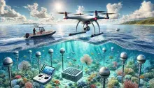
Exploring the Cutting-Edge Technologies Powering Our Journey

The circumnavigation of North and South America is more than just a voyage; it’s a scientific expedition fueled by groundbreaking technologies that deepen our understanding of the oceans and their role in our planet’s health. From drones capturing stunning aerial perspectives to advanced satellites monitoring marine ecosystems, these tools enable us to collect vital data and share discoveries in real time. Each technology plays a unique role, whether it’s mapping thermal patterns, tracking sea surface temperatures, or analyzing atmospheric conditions. Together, they empower us to unravel the mysteries of our interconnected ocean and inspire action for its stewardship.

High-resolution aerial imagery captured using advanced drones. This technology allows us to survey vast areas with precision, providing critical insights into landscapes, ecosystems, and hard-to-reach locations. From mapping coastal changes to monitoring wildlife, drone imagery offers a bird's-eye
microSWIFT expendable wave buoys are small, GPS-equipped floating sensors designed to measure wave and surface current data in real-time. These buoys are highly portable, inexpensive, and often used in large quantities to capture detailed oceanographic data over expansive areas. They are
Imagery from the Plankton, Aerosol, Cloud, ocean Ecosystem (PACE) satellite, designed to monitor ocean and atmospheric health. PACE imagery provides vital data on marine ecosystems, including phytoplankton populations and ocean color, helping scientists understand and protect our planet’s aquatic

ROV

An ROV (Remotely Operated Vehicle) is an uncrewed underwater robot controlled by an operator at the surface, often used for deep-sea exploration, underwater inspections, and marine industry tasks. ROVs are equipped with cameras, sensors, lights, and sometimes manipulator arms, allowing them to
Satellite imagery refers to images of Earth or other planets captured by imaging satellites orbiting in space. These images are collected using sensors on satellites that capture various types of data in different spectral bands, such as visible light, infrared, and radar. Satellite imagery is a
Infrared sensors that detect and measure heat emitted by objects and surfaces. This cutting-edge technology helps identify temperature variations, monitor environmental changes, and assess energy efficiency. Thermal IR sensors are crucial for detecting heat signatures in ecological studies and
An on-site instrument suite that measures key meteorological variables like temperature, humidity, wind speed, and barometric pressure. Weather stations deliver real-time data, helping predict weather patterns, support environmental research, and inform local decision-making.